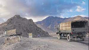
NEW DELHI: A new strategic road alignment in a vital portion of eastern Ladakh is set to be ready by next year. The military was already using sections of the road, the Ministry of Defence said today as it gave out details of the progress on the new road in its year-end review.
This is an alternative axis to reach Depsang and Daulat Baig Oldie (DBO) in the vital Sub-Sector North (SSN) along the Line of Actual Control (LAC) in eastern Ladakh. The Karakoram pass that leads to Xinjiang is also part of the SSN. India and China have been locked in a military standoff along the LAC since April 2020.
The new road alignment starts from Sasoma (on the Leh-Siachen base camp road) and goes eastwards across the 17,800-ft-high Saser La before going downwards to Saser Brangsa an old uninhabited camping ground on the Kashmir-Xinjiang trade route. From here, the road goes in two directions one eastwards to Murgo and the other northeast to Gapshan. Both the roads will join the existing 255-km Darbuk-Shyok-DBO (DSDBO) road at two separate locations.
In 2020, when China amassed troops across the LAC on its side, the Indian Army and the Border Roads Organisation (BRO) started opening up portions of the new alignment which is actually an old trade route used by mules. A mud track traversable by Jeep was created in 2020 from Sasoma to Saser La. Eastwards from Saser La to Saser Brangsa, the 16-km track only allowed walking. For Saser Brangsa and beyond till Murgo, a Jeep-able track was hurriedly laid out post 2020.
Since then, BRO has worked to widen the track. In April this year, bids were invited black-top 43 km of the Sasoma-Saser La stretch.
The work on making the alignment usable militarily kick-started after May 2022 when the National Board for Wildlife allowed the new alignment through 55 hectares of Karakoram wildlife sanctuary that is en route the new alignment. The road is vital as the existing alignment the DSDBO could be threatened.
The new alignment will provide additional access to the SSN. Indian Army has considered a scenario that the People’s Liberation Army (PLA) of China could make a westward thrust into the 16,000-ft-high Depsang plains in the SSN. The PLA could threaten a section of the DSDBO road. The Galwan valley is on the same stretch. The PLA could also attempt to cut off the DBO, which could restrict access to the Karakoram pass, or make a bid to access the Saser La.


