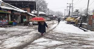
SRINAGAR: Jammu and Kashmir is set to experience a spell of rain and snow as a fresh Western Disturbance, currently developing over Afghanistan, moves towards the region by February 20. The disturbance is expected to bring widespread precipitation across the Union Territory.
According to weather predictions, the higher reaches of the region will be the first to witness the effects, with precipitation starting late on the night of February 19. The intensity of rain and snow is expected to increase as it spreads across both divisions of Jammu and Kashmir.
Most areas are likely to witness a moderate spell of rain or snow, with some parts potentially receiving heavy precipitation. Jammu region is expected to record higher rainfall compared to the Kashmir Valley, with the districts of Ramban, Kishtwar, and Doda in the Chenab Valley likely to receive moderate to heavy precipitation.
In Kashmir Valley plains, rainfall is expected to dominate initially. However, a sharp drop in temperatures might lead to snowfall, especially in cases of prolonged heavy precipitation. Temperatures, which are forecast to remain between 15 and 18°C on February 19, are expected to drop sharply to below 7°C on February 20.
The Pir Panjal range is anticipated to receive heavy snowfall, particularly affecting popular areas like Gulmarg, Sinthan Top, Peer Ki Gali, and regions along the Mughal Road.
With relatively higher temperatures prevailing, lightning and thundershowers are expected, particularly in the Jammu region. Additionally, the Jammu-Srinagar National Highway may face disruptions due to the potential for shooting stones and landslides.
Weather conditions are likely to improve from February 21 onwards, providing relief after the anticipated disturbance.