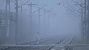
NEW DELHI: A layer of fog, stretching from Punjab to West Bengal, and lowered visibility over the Indo-Gangetic plains starting from Thursday night are affecting road and rail traffic, officials said on Friday.
Satellite imagery showed fog developing over parts of Punjab, Haryana, north Rajasthan and west Uttar Pradesh starting at 8 pm on Thursday.
An official at the India Meteorological Department (IMD) said dense to very dense fog blanketed parts of Punjab, Rajasthan, Haryana, Delhi and Tripura. Moderate fog prevailed in parts of Uttarakhand, east Uttar Pradesh, Bihar, Jharkhand and Odisha.
At 5.30 am, visibility levels stood at zero metre in Bathinda and Bikaner, 25 metres in Amritsar and Patiala, 50 metres in Ganganagar, Churu, Hisar, Palam, Safdarjung, Jaipur and Agartala, and 200 metres in Ambala, Dehradun, Sultanpur (east UP), Purnea, Bhagalpur, Ranchi and Jharsuguda.
A spokesperson for the Indian Railways said 22 trains arriving in Delhi were delayed by up to six and a half hours due to the foggy weather.
The IMD reported that the visibility level plummeted to zero metre at the Amritsar airport by 8 pm, while it abruptly dropped from 1,400 metres at 9.30 pm to 400 metres at 10 pm at the Palam Observatory, near the Indira Gandhi International Airport.
It further dropped to 50 metres by 11.30 pm and to zero metre by 4.30 am, before improving to 300 metres by 7.30 am.
Early morning foggy weather in north and northeast India has heavily impacted road, rail and air traffic since the end of December.
IMD scientists say the absence of active western disturbances — weather systems originating in the Mediterranean region and bringing unseasonal rainfall to northwest India — is the reason behind the blinding layer of fog persisting over the plains in northwest India since December 25.
Generally, five to seven western disturbances impact the region during December and January. But this winter, there have not been any so far, they said.
The minimum temperatures have been below 4 degrees Celsius at many stations in the region from January 12 to 17.
This severe weather is due to mainly three reasons: lack of active western disturbances over northwest India, prevailing El-Nino conditions, and a strong jet stream, they said.
Strong jet streams, which are bands of strong wind that generally blow from west to east all across the globe and impact weather, have been prevailing over north India for the last five days.
The IMD said “dense to very dense” fog conditions are likely to prevail over north India for the next five days.


